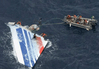
French investigators are to advise development of technical methods to reduce the search zone for missing aircraft, after the expensive two-year hunt for Air France flight AF447.
Uncertainty over AF447's location forced recovery teams to mark out a search circle 80nm (150km) in diameter - a total coverage area of 5,000nm² (17,000km²) - although the final wreck site was close to the last confirmed position.
The International Civil Aviation Organisation's flight recorder panel aims to require aircraft certificated from 2018 to carry equipment to limit searches over water to a 4nm radius.
Investigation agency BEA set up a technical working group that has concluded that the onset of an emergency could feasibly trigger transmission of aircraft data. The study also determined that higher-frequency position updates could significantly limit the size of a search radius.
The group examined 44 accidents and 24 incidents, across a broad range of aircraft types, to determine potential situations that could prompt a transmission.
Air France also supplied data on another 621 normal flights - comprising 212 conducted by Airbus A320s, 217 by A330s and 192 by Boeing 777s - to serve as a database for filtering out false triggers.
Analysis showed that simple binary triggering from unusual attitudes, such as excessive bank or pitch, as well as specific cockpit alarms, would have been effective for all but one of the 68 accidents, and would have limited nuisance alarms to two out of the 621 normal flights.
By including a time-limit criteria to check whether the emergency had stopped, the analysis found the false alarm rate could be limited to just 1min of nuisance transmission in 282h of flight. Using "fuzzy" logic to fine-tune the criteria could improve the detection rate and reduce nuisance alerts.
Eighty percent of the 44 accidents studied would have warned of a developing emergency at least 15s before impact, and for 34% the interval would have been at least 1min.
The warning time specifically for aircraft in cruise - as AF447 had been - notably increases, with 91% of accidents having a 30s interval, or more, between detection and impact.
"This study proves that developing reliable emergency detection criteria is achievable," said the BEA.
"The robustness of detection could be further improved with more elaborate criteria and additional parameters available on modern aircraft databuses."
BEA's working group also assessed the likelihood that triggered transmissions would be picked up and relayed by the Inmarsat constellation of communication satellites, when location and aircraft orientation were taken into account.
Simulations replicating 42 of the accidents in 597 different points of the world demonstrated that, in 85% of cases, transmission of data "would be possible before impact", said the working group.
For 82% of the accident and location combinations the corresponding search zone for the wreckage would be contained within a 4nm (7.4km) radius. This figure increases to 88% for impact points at the less extreme latitudes from 70°N to 70°S.
"Satcom systems with more than two antennas have the potential to perform extremely well in all aircraft environments, regardless of aircraft attitude," said the working group.
Much of the uncertainty over AF447's location resulted from the Airbus A330's automatically transmitting its position at 10min intervals. The working group has concluded that, by raising this frequency to once per minute, 85% of accidents in the study would have had an impact site within 4nm of last reported position.
This 4nm location radius is a "realistic aim" for 2020, said the group, and the BEA is "planning to issue a safety recommendation on this basis in the framework of the AF447 accident".
As part of its assessment the BEA has also inquired as to whether emergency locator transmitters could be developed to signal ahead of impact rather than activate on shock or water contact.
While the Cospas-Sarsat satellite system for search and rescue has been "undoubtedly helpful", said the working group, its detection of beacon signals after a crash "remains problematic" - either because of malfunction, submersion, obstruction or damage.
BEA sought advice from Cospas-Sarsat's operators to see whether beacons could transmit "a limited set of parameters" before an accident, and was invited to attend a meeting in Washington in September 2010 to draft initial operational requirements for next-generation beacons.
There have been previous similar suggestions, said the BEA, but the benefit has been impaired by limitations of Cospas-Sarsat's Leosar low-Earth orbit satellites, whose detection capability is "incompatible" with the typically short interval between an aircraft encountering distress and a resulting accident.
But this limitation "will disappear" with Cospas-Sarsat's medium-orbit Meosar system, it added. Initial testing shows localisation within 5km (2.7km) could be achieved with a single transmission burst.
The BEA adds that the time between beacon activation and initial data burst, currently specified at 50s, could be reduced to 3s to ensure data transmission initiates before a crash.
Cospas-Sarsat plans to approve operational requirements this year and compatible beacons could be available by the end of 2015. Meosar operational capability is expected in 2018.
Source: Flight International