


FlightGlobal is the global aviation community’s primary source of news, data, insight, knowledge and expertise. We provide news, data, analytics and advisory services to connect the aviation community globally and help organisations shape their business strategies, identify new opportunities and make better decisions faster.
Army helicopter was 100ft above mandatory flight ceiling during collision with PSA Airlines jet
By  Ryan Finnerty2025-02-05T19:25:00
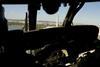
Preliminary data released by the USA’s National Transportation Safety Board indicates the incident Sikorsky UH-60 was flying around 300ft when it impacted a PSA Airlines regional jet – some 100ft above the altitude ceiling of 200ft for rotorcraft in the area.
Keep reading this article by becoming a FlightGlobal member now
PLEASE REGISTER FOR FREE OR SIGN IN TO CONTINUE READING

You have reached your limit of free articles for this period. Register for a FREE account to read this article and benefit from:
- Increased access to online news and in-depth articles from:
- FlightGlobal Premium covering the global aviation industry
- Airline Business providing insight for business leaders
- Weekly newsletters on topics across the industry