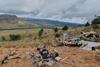
German investigators have disclosed that the Malawi air force Dornier 228-200 which crashed fatally while transporting the country’s vice-president had followed a meandering flightpath in poor weather after deviating from its course.

The aircraft had departed the capital Lilongwe for Mzuzu – about 150nm to the north – on 10 June, after picking up vice-president Saulos Chilima and his entourage.

Chilima was among six passengers on board the 228 which was also carrying three crew members.

German investigation authority BFU is leading the inquiry after responsibility was delegated by its Malawian counterpart.

BFU faces a tricky task: the aircraft was not equipped with a flight-data or cockpit-voice recorder – neither was required by law.

It adds that Lilongwe air traffic control radar data for the 228’s inbound and outbound flights was not recorded.

The inquiry has, however, accessed position and altitude information from a GPS navigation device on board the aircraft.

Given the lack of radar coverage at lower altitudes north of Lilongwe terminal airspace, BFU has also sourced mobile phone data of three occupants, to determine which radio cells connected with phone signals during the flight.

Do228 crash map-c-BFU

Source: BFU

As the aircraft neared Mzuzu it deviated from its direct course, instead following an erratic path

According to air traffic control, the crew had been given a direct route clearance to Mzuzu at 9,000ft and departed Lilongwe Kamuzu airport’s runway 14 at 09:16.

The aircraft turned north and appeared on radar at around 4,800ft. It climbed to 7,000ft where the crew requested to remain.

Within 15min radar contact had been lost owing to low altitude but the GPS data shows the aircraft, flying at 7,500ft, passed 3nm west of waypoint NALSA at 09:32 A few minutes later it began to climb, reaching 8,600ft, and then started to descend.

As it passed a village called Fumbawowa, around 09:50, the aircraft “began to deviate from the direct course to the destination” by entering a left turn, says BFU in preliminary findings.

It descended to 5,500ft before climbing again to 8,100ft. Elevation data indicates rapidly-rising terrain in the area. The aircraft headed west, then carried out a full left-hand orbit, before turning right to fly east.

Just before 10:00, while heading northeast, it descended to 5,400ft – a height of only 460ft – then climbed while continuing north. Some 3nm northwest of Chikangawa, between 10:06 and 10:09, it made two more tight left-hand orbits about 200-500ft above terrain.

The aircraft proceeded northeast but continuing to descend and climb. It was 25nm southwest of Mzuzu airport at 10:12, and flying at 7,000ft, before it turned north and began to descend again.

Weather conditions had been deteriorating at Mzuzu airport, with drizzle and fog present. BFU says the crew contacted Mzuzu tower to inform that they intended to approach from the north, and wanted to fly towards Ekwendeni to see if conditions were better.

But around 4min later, as the aircraft headed northwest, its right wing collided with a tree on a 6,360ft hill in the Chikangawa Forest. The fuselage struck the ground, breaking up and coming to rest about 80m beyond. There was no fire.

None of the nine occupants survived the impact.

Do228 crash site-c-BFU

Source: BFU

None of the nine occupants survived after the aircraft crashed into the slope after hitting a tree

Analysis of the wreckage showed the landing-gear had been extended and the flaps were partially deployed.

BFU states that the aircraft crashed in “marginal” conditions. It says it has requested meteorological information for the route, and specifically the crash site, from the German weather service.

The aircraft (MAF-T03) was delivered new to the Malawian defence forces in 1988.

While the inquiry has yet to reach conclusions on the cause of the accident, BFU has made safety recommendations to ensure aircraft crews have up-to-date information on navigation aids, after finding that the Malawian aeronautical information publication listed VOR/DME and NDB beacons which no longer existed as well as omitting an NDB located at Lilongwe.